


Murmansk Marine Biological Institute of RAS
Россия
Россия
Россия
Россия
Россия
Purpose. The paper aims to present the results of in situ measurements, analyze the features of variability of water characteristics in the northeastern part of the Greenland Sea with an emphasis on the Marginal Frontal Zone in winter based on the onboard measurement results, as well as to assess the agreement between the reanalysis data and the in situ observations. Methods and Results. The results of temperature and salinity measurements performed during the expeditionary research in the northeastern part of the Greenland Sea in winter periods of 2019–2023 are used in the paper. The temperature and salinity anomalies of the Atlantic waters are assessed by comparing the in situ data with the WOA-2023 climatic data. To evaluate the reanalysis quality, the data from the MERCATOR PSY4QV3R1, CMEMS GLORYS12v1 and TOPAZ5 products for the 0–40 m depths are involved. The comparison is carried out using the standard statistical methods: descriptive statistics, spatial correlation analysis and discrepancy function method. It is found that the studied frontal section between the Arctic and Atlantic waters could be traced up to 80 km from the ice edge. The maximum gradients of thermohaline characteristics in the Marginal Frontal Zone were recorded in 2023 under conditions of the significant positive temperature anomalies of surface waters of the Atlantic origin. It is shown that the reanalysis data describe accurately temperature and salinity only within the Atlantic water region. Conclusions. The results of in situ measurements confirm the existence of stable positive water temperature anomalies relative to the climatic values in the surface layer of the Greenland Sea northeastern part in winter, which influence the characteristics of hydrological field gradients in the Marginal Frontal Zone. Being compared, the temperature and salinity fields resulted from the observation and reanalysis data have shown that the latter lack the datasets which describe reliably the thermohaline characteristics of waters near the ice edge.
water temperature, water salinity, frontal zone, Marginal Frontal Zone, MERCATOR, GLORYS12v1, TOPAZ5, onboard observations, Greenland Sea
Introduction
The northeastern part of the Greenland Sea (the Fram Strait) adjacent to the Svalbard archipelago (Fig. 1) is characterized by the interaction of waters of the Atlantic and Arctic origin and is also affected by melt waters coming from the shores of West Spitsbergen Island. A significant part of the water and heat exchange between the Arctic basin and the World Ocean is carried out through the Fram Strait [1]. The Norwegian Current, which continues the North Atlantic Current and passes along the Norwegian slope, carries warm and salty Atlantic waters northwards into the Arctic Ocean. As it moves, the Norwegian Current is divided into two branches. One of them turns east into the Barents Sea and continues as the North Cape Current, the second branch moves along the Barents Sea western edge and the slope of Svalbard, becoming the core of the West Spitsbergen Current (WSC) divided into three branches. The western branch circulates mainly in the western and southwestern directions. The central WSC branch moves north over the shallow Yermak Plateau. The easternmost branch (the Spitsbergen branch) continues moving over the Svalbard northern slope and circulates cyclonically, submerging under freshened and cold Arctic waters [2, 3].
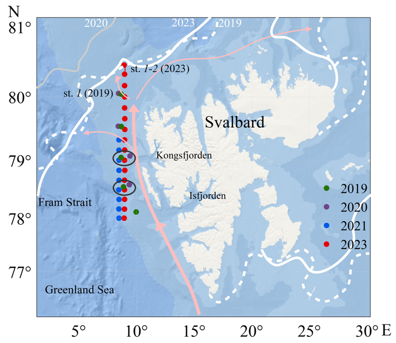
F i g. 1. Map of study area. Position of CTD sensing stations are shown by colored dots, areas of monitoring points – by black ellipses, position of currents – by pink arrows, position of ice edge in 2019 and 2023 – by solid and dashed white lines, position of ice edge in 2020 – by solid gray line
The Мarginal Ice Zone (MIZ) is defined as a transition zone between ice-free sea and dense drift ice and extends from the imaginary line where 15% of the sea surface is covered by ice to the position of 80% ice cover concentration isoline [4]. Inside or outside the MIZ, a Marginal Frontal Zone (MFZ) is usually observed, the existence of which is due to the interaction of relatively freshened cold Arctic waters formed as a result of ice melting and transformed Atlantic waters in an area located at a distance of several tens of kilometers from the ice edge [5]. Studies carried out in the Barents Sea MIZ in the spring of 2023 showed that the MFZ could be located units to hundreds of kilometers from the ice edge [6].
Complex and multi-scale processes of interaction in the ocean – sea ice – atmosphere system occur in the MFZ area. It is believed that atmospheric processes can significantly affect thermohaline structure variability in the area westwards and northwestwards of Svalbard [7]. In [8], the authors consider the MIZ position variability under effect of ocean dynamics associated with eddy structures recorded in the Fram Strait according to satellite radar observations. It is shown that ice edge displacement and eddy formation intensity are determined by the impact of wind conditions. In [9], it is found that tidal currents affect the variability of ice edge position and, accordingly, the MIZ characteristics. In this case, bottom relief gradients cause anomalies in the velocity of tidal currents, which is reflected in the marginal zone characteristics regardless of wind effect intensity. All the mentioned processes impact the parameters of turbulent flows; their consideration is important for qualitative description and forecasting of hydrometeorological conditions in the Arctic [10].
Global ocean models supplemented by ocean data reanalysis systems are constantly evolving and their results are shared openly in the form of quickly updated databases [11, 12]. In [13], it is noted that the main cause for the errors of ocean models in the Arctic region simulation is the use of subgrid process parameterization developed for mid-latitudes. Created sets of spatio-temporal values of water characteristics from these databases are often used (considering them verified) when solving applied problems, including those related to the detection of frontal zones [14] or recording changes in the available potential and kinetic energy of mesoscale eddies [15]. At the same time, a comparison of shipboard and model data for the region under study is not carried out, which does not always seem correct [16]. In [17], the results of oceanographic observations in the Arctic Ocean northwards of Svalbard are examined. In particular, a comparison with climate data from the Monthly Isopycnal/Mixed-layer Ocean Climatology (MIMOC) with 0.5° spatial resolution is performed. It was found that the upper layer of waters of the Atlantic origin was warmer and saltier according to observations than it was shown by the MIMOC climate data. Quality assessment of reconstruction of surface water characteristics by ocean databases according to repeated shipboard observations in the northeastern Greenland Sea in winter has not been previously carried out.
Thus, the work is purposed at analyzing the results of unique shipboard measurements for the winter period of 2019, 2020, 2021 and 2023, identifying the variability features of water characteristics in the northeastern Greenland Sea with an emphasis on the MFZ area as well as assessing the compliance of quickly updated ocean databases with the observation results.
Data and methods
The work is based on the data from ice edge visual observations and CTD sensing obtained during the expeditions of Murmansk Marine Biological Institute of RAS on R/V Dalnie Zelentsy in winter of 2019, 2020, 2021 and 2023. Measurements of main hydrological parameters of marine environment were carried out by the CTD profiling method using the SEACAT SBE 19 plus V2 CTD probe. The studies were carried out on sections located in the waters northwestwards of Svalbard (Fig. 1) in the following periods: 20–21 November 2019, 6–7 November 2020, 23–25 November 2021 and 4–5 December 2023. To verify the results of ice edge visual observations carried out from the vessel, we used ice cover position data with a spatial resolution of 1/4° prepared by the University of Bremen [18]. The isoline corresponding to 80% ice concentration was taken as the boundary of the ice edge position. It should be noted that the sections were made in relative proximity to the ice edge only in 2019 and 2023. In particular, in 2023, R/V Dalniye Zelentsy managed to come close to a field of large-sized ice with a concentration of 7–8 points. At the same time, CTD sensing was carried out directly in an area where the concentration did not exceed 1–2 points (visual observations from the vessel) with almost no risk of losing the sensing equipment. Those were the data that were used to describe the characteristics of the MFZ area waters. In 2020 and 2021, the northern points of the sections were located 144 and 141 km to the south of the ice edge, respectively; these data were used to assess the interannual variability of hydrological characteristics in this area.
To describe the variability of hydrological conditions, we used the data from two monitoring groups of stations (with their positions coinciding practically (Fig. 1)) carried out during the expeditions of 2019, 2020, 2021 and 2023. At these stations, for the upper layer (0–40 m), we estimated the deviation of in situ results from the climatic values of temperature and salinity given on the website https://www.ncei.noaa.gov/access/world-ocean-atlas-2023/bin/woa23.pl from the World Ocean Atlas 2023 over the thirty-year period from 1991 to 2020 with 1/4° spatial resolution.
The following reanalysis products were applied to compare the CTD sensing results with the data of operational ocean models:
- CMEMS GLORYS12v1 (GLOBAL_MULTIYEAR_PHY_001_030 / E.U. Copernicus Marine Service Information (CMEMS). Marine Data Store (MDS). https://doi.org/10.48670/moi-00021 (date of access: 05.02.2024));
- MERCATOR PSY4QV3R1 (GLOBAL_ANALYSISFORECAST_PHY_001_024 / Global Ocean Physics Analysis and Forecast. Marine Data Store (MDS). https://doi.org/10.48670/moi-00016 (date of access: 05.02.2024));
- TOPAZ5 (ARCTIC_ANALYSISFORECAST_PHY_002_001 / Arctic Ocean Physics Analysis and Forecast. Marine Data Store (MDS). https://doi.org/10.48670/moi-00001 (date of access: 05.02.2024)).
Selection of GLORYS12v1, PSY4QV3R1 and TOPAZ5 was determined by the availability of high spatial and temporal data resolution for the study area. GLORYS12v1 provided by Copernicus Marine Environment Monitoring Service is a global ocean reanalysis with daily discreteness and a spatial resolution of 1/12°. PSY4QV3R1, the European Group operational system for analysis and forecasting of the World Ocean, is characterized by a similar resolution. TOPAZ5 daily dataset, which uses the HYCOM model, contains information for the Arctic region with 6.25 km spatial resolution of output data. Quantitative comparison was performed using the methodology described in detail in [16], according to which uniform arrays with the reduction of reanalysis and measurements data to uniform coordinates, horizons and dates of execution of each of the selected stations were formed. For comparison, two arrays were formed: the first one for the area of monitoring points of the region influenced by the Atlantic waters and the second one for the MFZ region where the interaction of the Arctic and Atlantic waters occurs. Then, a comparison of arrays was carried out by the average weighted values of temperature and salinity, divergence function, anomaly and correlation coefficient. To interpret divergence function (F), the classification proposed in [19] was applied: 0 ≤ F < 1 (good), 1 ≤ F < 2 (satisfactory) and 2 ≤ F (poor).
Results and discussion
To analyze the interannual dynamics of temperature and salinity over a short interval (2019–2023), two monitoring areas (Fig. 1) were selected – northern and southern – within which hydrological stations were located at the closest possible distance from each other. The stations of the monitoring areas had a depth range from 45 to 1000 m (Fig. 2) since they were located at some distance from each other in the continental slope area. In general, at all the stations under consideration, the temperature varied within the range of 0.5–5.8 °C and the salinity varied within 33.4–35 PSU. The impact of cold and desalinated waters carried out from Kongsfjorden and Isfjorden of West Spitsbergen Island was observed in the upper 20 m layer at the stations that were closer to Svalbard. The easternmost position, correspondingly closer to Svalbard, was occupied by the stations completed in 2020. Here, at the 0 m horizon, the lowest temperature values of 1.45 °C and salinity of 33.45 PSU were observed. The southern group of stations was characterized by average temperature and salinity values of 4.2 °C and 34.8 PSU in the upper 40 m layer. Within the northern group of stations, similar average values were lower by 1.4 °C and 0.4 PSU. At the station from the northern group completed in 2023, a pycnocline was observed at a depth of 120 m; its existence was also due to the mixing of the WSC waters with the coastal Svalbard waters in shallow area.
To identify the relationship between the variability of thermohaline characteristics at the oceanographic stations under consideration and larger-scale processes over a given time interval, surface air temperature at meteorological stations on Svalbard and anomalies of water temperature and salinity in the monitoring areas were used. These anomalies were calculated relative to the climatic values from the World Ocean Atlas averaged over a 30-year period. The climatic values of temperature and salinity were calculated as average values over a 30-year period in the measurement months (November, December) averaged for each of the monitoring areas. Analysis of surface air temperature anomalies at meteorological stations in populated areas of Svalbard revealed significant warming in the winter period (after the “normal” period of 1960–2000) of 2000–2021 [20, 21]. Surface air temperature anomalies reached 3–6 °C. The WSС waters in the monitoring areas were characterized by positive temperature anomaly in the winter period from 2019 to 2023 (Fig. 3). Salinity anomaly value was close to the climatic norm in 2021 and 2023 and negative in 2019 and 2020 (−0.1 and −0.9, respectively). In 2020, significant negative salinity anomaly and low temperature anomaly were observed. The coastal waters of Svalbard had an impact during this period; their temperature and salinity values were lower due to the influence of river runoff mainly of glacial and snow feeding and seasonal melting.
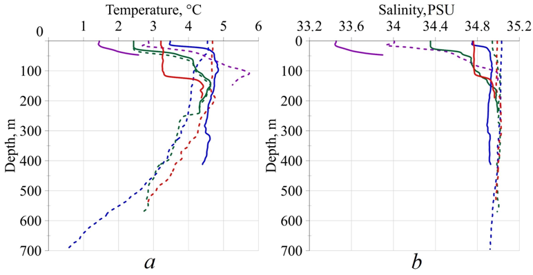
F i g. 2. Vertical profiles of water temperature and salinity at monitoring stations (stations of the northern group of points are marked with solid line, those of the southern group – by dotted line; stations completed in 2019 – by green line, in 2020 – by purple line, in 2021 – by blue line, in 2023 – by red line)
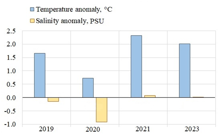
F i g. 3. Distribution of temperature and salinity anomalies in the monitoring areas during the winter periods in 2019–2023
Comparison of in situ and reanalysis data in monitoring areas located mainly in the Atlantic Ocean waters showed that PSY4QV3R1 and TOPAZ5 describe the temperature and salinity of the WSС waters in the best possible manner. The discrepancy function with in situ data for all products as a whole had values close to zero, which corresponded to a “good” comparison result, and high significant correlation coefficients were also noted (Table 1). Statistical significance of relationship between the measured and model data series was determined at a significance level of 0.05. Since the calculated Student t-test varied within 2–5 and was less than the critical value (1.97–1.98), the discrepancies in the mean were significant. On average, the dispersion of the temperature series of measured data was 1°С^2 and for the reanalysis data – 0.8 °С^2. The salinity dispersion of in situ observations was 0.5 PSU^2 while it was two times smaller for the reanalysis – 0.25 PSU^2. The reanalysis data indicated smoother temperature and salinity profiles in the coordinates under consideration, underestimating the values of real dispersion of the series. GLORIS12v1 reconstructed temperature and salinity of waters somewhat worse: average temperature for the series was overestimated by 0.7 °C, salinity – by 0.3 PSU; however, the correlation coefficient was quite high, the divergence function fell into the range of “good” values. In general, all three reanalysis datasets demonstrated a good result of reconstructing the thermohaline characteristics in the waters of the Atlantic origin.
T a b l e 1
Statistical characteristics for comparing the data obtained at the monitoring stations located in the West Svalbard Current waters
|
Reanalysis |
Average value (in situ) |
Average value (reanalysis) |
Anomaly |
Cost function |
Correlation coefficient |
|
|
Temperature, °С |
||||||
|
PSY4QV3R1 |
3.54 |
3.49 |
0.05 |
0.05 |
0.80 |
|
|
GLORIS12v1 |
3.47 |
4.17 |
−0.70 |
0.69 |
0.79 |
|
|
TOPAZ5 |
3.53 |
3.44 |
0.09 |
0.09 |
0.90 |
|
|
Salinity, PSU |
||||||
|
PSY4QV3R1 |
34.54 |
34.68 |
−0.14 |
0.24 |
0.95 |
|
|
GLORIS12v1 |
34.55 |
34.83 |
−0.28 |
0.58 |
0.91 |
|
|
TOPAZ5 |
34.58 |
34.75 |
−0.17 |
0.33 |
0.96 |
|
The differences between the MIZ and surrounding waters consist in the presence of a thin freshened layer on the surface formed as a result of sea ice melting as well as the presence of convection and attenuation of wind waves and swell [22]. Within this area, in the northeastern Greenland Sea in the winters of 2019 and 2023, the MFZ was recorded by contact sensing data from a vessel. Fig. 4 represents the vertical distribution of temperature and salinity on the hydrological sections. Measurements in 2019 and 2023 were carried out with different spatial steps. The first station of the section performed in 2019 is located opposite Isfjorden Bay at 10°E, the other four stations of the section passed along 8.9°E to 80°N. In 2023, CTD sensing stations were performed along the meridian (9°E) with a resolution of 10 nautical miles from 78°N towards the ice edge (at 80°30'N). The sections are directed along the West Spitsbergen Current, in the northern part they cross the MFZ and the Arctic waters. The stations are numbered from the northern station of the section. Water temperature on the section in 2019 varied within the range of −0.5...4.7 °C, salinity – 34–35 PSU. In 2023, the range of variability of thermohaline characteristics was −1.3...4.8 °C and 33.5–35 PSU. The layer of desalinated waters with negative temperature formed in the MIZ was separated by a pycnocline from the underlying transformed Atlantic waters at a depth of 10–30 m (Fig. 4). The frontal section, reflecting the position of the maximum temperature and salinity gradients, repeated the pycnocline outlines. Fig. 4 shows that the frontal section conventional line is drawn along the nearest isolines of hydrological characteristics.
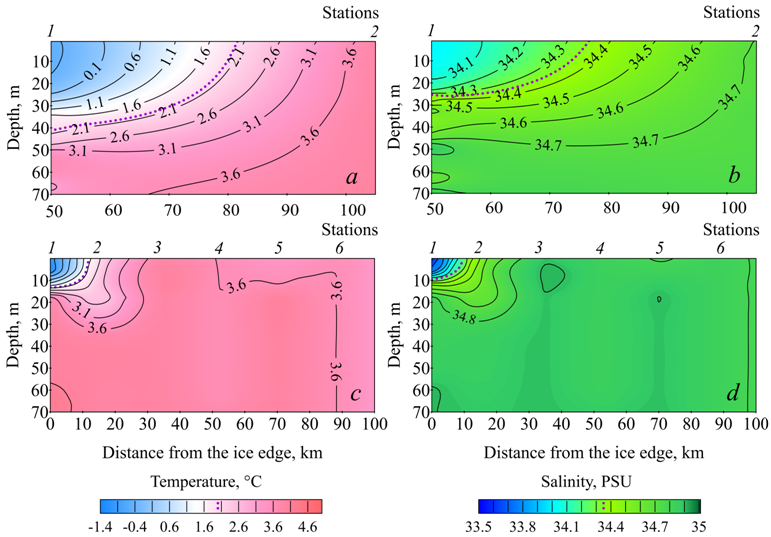
F i g. 4. Vertical distribution of temperature (left) and salinity (right) in the Marginal Frontal Zone on the sections in 2019 (a, b) and 2023 (c, d). Purple dotted line denotes the isotherm and isohaline along which the frontal sections of temperature and salinity run
On the section performed in 2019, the cold freshened Arctic waters (temperature < 0 °C, salinity < 34 PSU) were observed at the northern station in the upper 30 m layer, underlain by warmer and saltier waters of the West Spitsbergen Current (temperature > 3 °C, salinity > 34.5 PSU). During the study period, the horizontal temperature gradient between stations 1 and 2 reached 0.08 °C/km in the upper 20 m layer and decreased to zero values by the 90 m horizon, below which the temperature leveled off in the underlying warm layer of the Atlantic waters. The horizontal salinity gradient in the upper 20 m layer was 0.01 PSU/km, decreasing to zero at the 46 m horizon. The frontal boundary here was located between the stations at a distance of 30 km from the northernmost station and 80 km from the supposed ice edge according to the University of Bremen. The frontal zone depth did not exceed 70–80 m.
In 2023, the Arctic waters were traced in the upper 10 m layer. The horizontal temperature gradient between stations 1 and 3 reached 0.15 °C/km at the sea surface and decreased to zero at a depth of 30 m. The salinity gradient decreased from 0.04 PSU/km at the surface to zero at a depth of 20 m. The maximum temperature and salinity gradients were observed between stations 1 and 3 and amounted to 0.24 °C/km and 0.07 PSU/km. If the frontal division is drawn along this line, it will be located 7 km from the field of large-sized ice with a concentration of 8 points. The frontal zone depth did not exceed 30 m.
The results of contact measurements were compared with the reanalysis data for the stations in the distribution area of the Arctic waters and the MFZ. In 2019, only the northern station of the section (station 1) was in the frontal zone; in 2023, the northern station was in the zone of the surface Arctic waters and station 2 was in the frontal zone (Fig. 1). The models here overestimated temperature and salinity by an average of 1–3 °C and 0.2–0.6 PSU. The correlation coefficient had small values but it was statistically significant for all compared pairs of series, except for the case of comparing the measured salinity with the TOPAZ5 data. The discrepancy function had “satisfactory” values when using PSY4QV3R1 and GLORIS12v1. TOPAZ5 regional reanalysis demonstrated a “good” divergence function with low correlation coefficients, indicating low ability of the models to reconstruct the vertical variability trend of water temperature and salinity (Table 2).
T a b l e 2
Statistical characteristics for comparing the data obtained
in the Arctic waters zone and the Marginal Frontal Zone
|
Reanalysis |
Average value (in situ) |
Average value (reanalysis) |
Anomaly |
Cost function |
Correlation coefficient |
|
|
Temperature, °С |
||||||
|
PSY4QV3R1 |
1.75 |
–0.81 |
3.12 |
1.39 |
0.54 |
|
|
GLORIS12v1 |
1.10 |
2.91 |
–1.20 |
1.01 |
0.62 |
|
|
TOPAZ5 |
0.63 |
2.07 |
–0.69 |
0.95 |
0.27 |
|
|
Salinity, PSU |
||||||
|
PSY4QV3R1 |
34.44 |
33.66 |
0.78 |
1.79 |
0.54 |
|
|
GLORIS12v1 |
34.33 |
34.73 |
–0.40 |
1.00 |
0.65 |
|
|
TOPAZ5 |
34.25 |
34.17 |
0.08 |
0.22 |
0.38 |
|
Fig. 5 represents the water temperature and salinity profiles at station 2 located within the MFZ on the section in 2023. The reanalysis data of PSY4QV3R1 and TOPAZ5 revealed a significant underestimation of values (> 2 °C and > 1 PSU) in the upper 7–15 m layer. That is, according to them, the distribution of the Arctic waters is observed at a greater distance than it was recorded by sensing data. On the contrary, GLORIS12v1 reanalysis showed a profile with values more typical of the Atlantic waters (temperature > 4 °C, salinity » 35 PSU) and their distribution by depth.
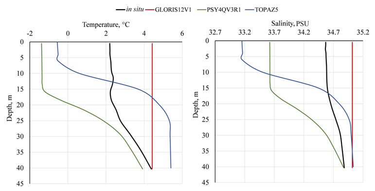
F i g. 5. Vertical distribution of temperature (left) and salinity (right) based on the in situ measurement and PSY4QV3R1, GLORIS12v1 and TOPAZ5 reanalysis data at station 2 on section in 2023
Average dispersion value (1.7 °C^2) of temperature series according to measurement and reanalysis data differed by hundredths of a degree. Salinity dispersion was 0.4 PSU^2 according to in situ data and 0.5 PSU^2 according to the reanalysis data. The MFZ area was characterized by high variability of temperature and salinity, which was reflected in the reanalysis data, but they did not reconstruct width, depth, frontal section position and values of temperature and salinity gradients of frontal zone waters with sufficient accuracy. The temperature divergence function calculated for the MFZ by the reanalysis data was four times smaller than in the monitoring areas and that of salinity was 2.6 times smaller. The maximum model temperature deviation from that measured in the MFZ was 35 times greater than that in the WSC waters and that of salinity was three times greater. This also reflects the presence of significant errors in reconstructing the hydrological parameters near the ice edge by the models.
Comparison of in situ measurement data with the data from MERCATOR PSY4QV3R1, CMEMS GLORYS12v1 and TOPAZ5 revealed that the latter have good agreement of temperature and salinity values in the West Spitsbergen Current waters while the freshened cooled Arctic waters and the frontal zone between them (Arctic and Atlantic) are poorly reconstructed.
Conclusion
The considered winter periods of 2019–2023 were generally characterized as “warm” ones, with positive water temperature anomalies ranging from 0.7 °C in 2020 to 2.3 °C in 2021. The water temperature anomaly recorded in 2023 exceeded the similar one in 2019 by 0.6 °C.
In 2019, the frontal section was located 80 km from the ice edge and the MFZ was observed in the upper 30 m water layer. In 2023, the frontal section was recorded 10 km from the ice edge and the MFZ occupied the upper 10 m layer. Higher temperature gradients (0.08–0.24 °C/km) on the section in 2023 were also due to the increased temperature anomaly of the West Spitsbergen Current relative to 2019.
It was shown that the thermohaline characteristics of waters in the Marginal Frontal Zone area in the Greenland Sea northeastern part in winter had a complex structure and their description could not currently be based only on the data of global oceanographic models. The use of reanalysis data requires their careful verification and balanced approach. Only a comprehensive method with regard to all forms of available hydrological data will provide reliable information for assessing the variability of hydrological conditions in the Marginal Frontal Zone.
1. Walczowski, W. and Piechura, J., 2011. Influence of the West Spitsbergen Current on the Local Climate. International Journal of Climatology, 31(7), pp. 1088-1093. https://doi.org/10.1002/joc.2338
2. Rudels, B., Korhonen, M., Budéus, G., Beszczynska-Möller, A., Schauer, U., Nummelin, A., Quadfasel, D., and Valdimarsson, H., 2012. The East Greenland Current and Its Impacts on the Nordic Seas: Observed Trends in the Past Decade. ICES Journal of Marine Science, 69(5), pp. 841-851. https://doi.org/10.1093/icesjms/fss079
3. Koenig, Z., Kolås, E.H. and Fer, I., 2021. Structure and Drivers of Ocean Mixing North of Svalbard in Summer and Fall 2018. Ocean Science, 17(1), pp. 365-381. https://doi.org/10.5194/os-17-365-2021
4. Strong, C., Foster, D., Cherkaev, E., Eisenman, I. and Golden, K.M., 2017. On the Definition of Marginal Ice Zone Width. Journal of Atmospheric and Oceanic Technology, 37(7), pp. 1565-1584. https://doi.org/10.1175/JTECH-D-16-0171.1
5. Rodionov, V.B. and Kostyanoi, A.G., 1998. Oceanic Fronts of the Seas of the North European Basin. Moscow: GEOS, 290 p. (in Russian).
6. Maksimovskaya, T.M., Zimin, A.V. and Moiseev, D.V., 2023. Results of Oceanographic Studies in the Marginal Ice Zone of the Barents Sea in the Spring of 2023. Fundamental and Applied Hydrophysics, 16(4), pp. 87-93. https://doi.org/10.59887/2073-6673.2023.16(4)-7 (in Russian).
7. Selyuzhenok, V., Bashmachnikov, I., Ricker, R., Vesman, A. and Bobylev, L., 2020. Sea Ice Volume Variability and Water Temperature in the Greenland Sea. The Cryosphere, 14(2), pp. 477-495. https://doi.org/10.5194/tc-14-477-2020
8. Petrenko, L.A. and Kozlov, I.E., 2023. Variability of the Marginal Ice Zone and Eddy Generation in Fram Strait and near Svalbard in Summer Based on Satellite Radar Observations. Physical Oceanography, 30(5), pp. 594-611.
9. Watkins, D.M., Bliss, A.C., Hutchings, J.K. and Wilhelmus, M.M., 2023. Evidence of Abrupt Transitions between Sea Ice Dynamical Regimes in the East Greenland Marginal Ice Zone. Geophysical Research Letters, 50(15), e2023GL103558. https://doi.org/10.1029/2023GL103558
10. Semenov, V.A., 2021. Modern Arctic Climate Research: Progress, Change of Concepts, and Urgent Problems. Izvestiya, Atmospheric and Oceanic Physics, 57(1), pp. 18-28. https://doi.org/10.1134/S0001433821010114
11. Donlon, C., Martin, M., Stark, J., Roberts-Jones, J., Fiedler, E. and Wimmer, W., 2012. The Operational Sea Surface Temperature and Sea Ice Analysis (OSTIA) System. Remote Sensing of Environment, 116, pp. 140-158. https://doi.org/10.1016/j.rse.2010.10.017
12. Carton, J.A., Chepurin, G.A. and Chen, L., 2018. SODA3: A New Ocean Climate Reanalysis. Journal of Climate, 31(17), pp. 6967-6983. https://doi.org/10.1175/JCLI-D-18-0149.1
13. Repina, I.A., Artamonov, A.Yu., Varentsov, M.I. and Khavina, E.M., 2019. Air-Sea Interaction in the Arctic Ocean from Measurements in the Summer-Autumn Period. Russian Arctic, (7), pp. 49-61. https://doi.org/10.24411/2658-4255-2019-10075 (in Russian).
14. Akhtyamova, A.F. and Travkin, V.S., 2023. Investigation of Frontal Zones in the Norwegian Sea. Physical Oceanography, 30(1), pp. 62-77.
15. Malysheva, A.A. and Belonenko, T.V., 2023. Variability of Potential and Kinetic Energy of Mesoscale Eddies in the Cape Basin. Journal of Hydrometeorology and Ecology, (73), pp. 684-698. https://doi.org/10.33933/2713-3001-2023-73-684-698 (in Russian).
16. Zimin, A.V., Atajanova, O.A., Konik, A.A. and Gordeeva, S.M., 2020. Comparison of Hydrography Observations with Data of Global Products in the Barents Sea. Fundamental and Applied Hydrophysics, 13(4), pp. 66-77. https://doi.org/10.7868/S2073667320040061 (in Russian).
17. Meyer, A., Sundfjord, A., Fer, I., Provost, C., Robineau, N.V., Koenig, Z., Onarheim, I.H., Smedsrud, L.H., Duarte, P. [et al.], 2017. Winter to Summer Oceanographic Observations in the Arctic Ocean North of Svalbard. Journal of Geophysical Research: Oceans, 122(8), pp. 6218-6237. https://doi.org/10.1002/2016JC012391
18. Spreen, G., Kaleschke, L. and Heygster, G., 2008. Sea Ice Remote Sensing Using AMSR-E 89 GHz Channels. Journal of Geophysical Research: Oceans, 113(C2), C02S03. https://doi.org/10.1029/2005JC003384
19. Eilola, K., Markus Meier, H.E. and Almroth, E., 2009. On the Dynamics of Oxygen, Phosphorus and Cyanobacteria in the Baltic Sea; A Model Study. Journal of Marine Systems, 75(1-2), pp. 163-184. https://doi.org/10.1016/j.jmarsys.2008.08.009
20. Karandasheva, T.K., Demin, V.I., Ivanov, B.V. and Revina, A.D., 2021. Air Temperature Changes in Barentsburg (Svalbard) in XX–XXI Centuries. Justification for Introducing a New Climate Standard. Russian Arctic, 2(13), pp. 26-39. https://doi.org/10.24412/2658-4255-2021-2-26-39 (in Russian).
21. Ilyushenkova, I.A., Korzhikov, A.Ya. and Ivanov, B.V., 2023. Some Patterns of Formation of Extreme Surface Air Temperature in the Area of the Spitzbergen (Svalbard) Archipelago during the Cold Period. Arctic and Antarctic Research, 69(2), pp. 141-156. https://doi.org/10.30758/0555-2648-2023-69-2-141-156 (in Russian).
22. Ilyin, G.V., Usyagina, I.S., Kasatkina, N.E., Valuiskaya, D.A. and Deryabin, A.A., 2017. Distribution of Radionuclides in the Marginal Ice Zone of the Barents Sea (Results of a Cruise in 2016). Transactions of the Kola Science Center of the Russian Academy of Sciences: Oceanology, 2(4), pp. 101-111 (in Russian).