


Россия
Россия
Purpose. The main purpose of the study is to analyze the long-period variability of the circulation characteristics of coastal waters in the Black Sea when assessing their energy contribution based on the long-term contact monitoring data on coastal currents. Methods and Results. The variability of kinetic energy of long-term oscillations of the coastal current off the Southern Coast of Crimea is analyzed based on the materials for 2002–2023 of the oceanographic database of Marine Hydrophysical Institute, RAS. The features of structure of the coastal water long-period oscillations are studied using the methods of statistical and spectral analysis of the energy variability of along-coastal current circulation in the 5–20 m layer over a 22-year measurement period. Within the intra-annual range of current variability, the energy contribution of seasonal oscillations is statistically reliably systematized for the periods 1.0, 0.5, 0.33 and 0.2 years. The results of analyzing the vector-averaged data made it possible to identify the spectral composition both of long-term current oscillations for the periods 2.7, 3.6, 5.3, 7.1 years and 11-year oscillations within the 22-year variability cycle. The spectral composition of coastal current inter-annual oscillations was compared to the North Atlantic Oscillation index. During the period of solar activity intensification in 2007–2020, a 1.5-fold increase in the values of velocity modulus of the coastal current inter-annual oscillations was noted. Conclusions. The long-period oscillations of coastal current including a range of short-term climatic oscillations were identified and systematized based on the results of analyzing the long-term field data obtained off the Black Sea coast. The prospects for further investigating the relations between such current oscillations and long-term circulation processes in the atmosphere of the Black Sea region are shown.
coastal current, long-period oscillations, short-term climate oscillations, energy spectrum of oscillations, contact measurements, Southern Coast of Crimea, Black Sea
Introduction
A fundamental understanding of the local features of the dynamics of the Black Sea coastal waters in the areas of conjugation with land is imperative to ensure sustainable economic development of the coastal region concentrated near the sea. This includes the near water area of the continental shelf, gulfs, bays, and estuaries. In the Black Sea shelf zone, the development of water dynamics is primarily caused by the formation of hydrodynamic disturbances of the Black Sea Rim Current (RC), particularly multi-scale anticyclonic and cyclonic eddy structures, including quasi-stationary ones [1–8]. At the same time, along-coastal currents have been observed everywhere under conditions of various geomorphological structures of land and bottom topography of the adjacent water area. According to the data systematized in the Black Sea Pilot the currents adjacent to rectilinearly oriented coastal sections exhibit a cyclonic direction, as does the jet RC abeam of the adjacent coastal section.
At a relatively straight section of the coastline of Cape Kikineiz of the Southern Coast of Crimea (SCC), which has a smooth outline, where the Goluboy (Limensky) Gulf slightly juts into the land, in the sea at a distance of ~ 0.5 km and a depth of 28 m, the regime characteristics of a quasi-stationary along-coastal current and a number of its intra-annual oscillations were identified and studied [9, 10]. In this case, the elliptical orbital movements of the shelf waters [3] are transformed near the coast into reciprocating along-coastal current oscillations [11].
As is known [12–17], the seasonal variability of the Black Sea hydrosphere transforms regional circulation processes in the atmosphere, including the surface wind field in the zone underlying the atmosphere of the sea and land surface. The surface stress of the wind field and its vorticity significantly affect the physical processes in the coastal zone of the sea, as evidenced by the formation of multiscale variability of the along-coastal current, including regular generation of packets of anticyclonic inertial oscillations. Mesoscale disturbances in the circulation of coastal waters, interacting with intense inertial oscillations, form a bimodal distribution regime of the frequency of monomodal current directions throughout the coastal zone depth [10, 17]. The nature of the circulation and transport of coastal waters in the west-southwest direction along Cape Kikineiz is observed year-round, with average annual velocities ranging from 5.8 to 9.4 cm/s [9].
The objective of this study is to conduct an analytical investigation into the long-term variability of the circulation characteristics of coastal waters in the Black Sea based on the data obtained from long-term contact monitoring of coastal currents. The primary goal is to systematize the structure of long-term oscillations and assess their energy contribution. The study’s new empirical findings contribute to the development and verification of a model forecasting system for the dynamics of coastal waters at sub-satellite polygons in the Black Sea [18] and system modeling of marine ecological and economic processes in the coastal zone near the South Coast of Crimea [19].
Materials and methods
A study of the energy spectral characteristics of long-term oscillations of coastal waters was conducted using the materials from the oceanographic database of Marine Hydrophysical Institute (MHI) of RAS [20]. These materials were obtained over a 22-year period of contact measurements of the current field characteristics near Cape Kikineiz, SCC. Instrumental measurements of the variability of the vertical structure of currents were carried out using a set of vector-averaging Eulerian meters installed in the active layer at hydrological horizons from the oceanographic platform of MHI Black Sea Hydrophysical Subsatellite Polygon [9–11]. A schematic map of the study area showing bathymetry, platform position, and arrangement of the vertical antenna of the cluster of meters is given in Fig. 1 in [11, p. 508]. The meters record chronological sequences of vector-averaged pairs of horizontal current components calculated over a 5-minute interval. The calculation is based on second-by-second readings of orthogonal projections of the current vector. The study uses current monitoring data collected from 2002 to 2023 at standard hydrological horizons (hereinafter referred to as “horizons”) of 5, 10, 15, and 20 m. Vector-averaged hourly averages and 8,035 pairs of mean daily readings for each measuring horizon are derived from the initial vector data arrays that have undergone a quality control procedure. The mean hourly database is presented in dbf-format and registered as the result of intellectual activity of MHI [9, 10]. The database volume for 8,035 days amounted to 771.4 thousand pairs of mean hourly values of the corresponding current vector components.
A long-term, full-scale experiment is carried out in open sea conditions, with continuous quality control of the functioning of domestic measuring complexes. Information technology is used for operational quality control of measurements, with a certain redundancy of the full data set from a set of meters installed from the pile foundation of a stationary oceanographic platform. This approach permitted to exclude the contribution of failures, significant methodological and systematic errors to the total error of current measurements. The metrological unity of a long-term set of vector data obtained under uniform conditions and means of instrumental measurements of currents, after averaging the original arrays, allowed minimizing their random errors to the sensitivity values of the corresponding primary measuring transducers of the complexes. In this case, the total error of the vector-averaged values of the velocity module does not exceed 0.1 cm/s, and the direction of the current – 3° [10, 17].
A software module has been developed at MHI for the purpose of spectral analysis. This module has been applied in the context of studies examining energy variability and spatiotemporal characteristics of wind fields, currents, long-wave motions, and internal waves [9–10, 15–18]. The essence of the used filter (linear) estimate of the energy spectrum is described in the work When processing the statistical characteristics of the vertical distribution of horizontal components of the current velocity, the method of analytical filtering of vector data was used [21]. Vector filtering of time series is also employed to minimize distortions that arise when calculating spectral characteristics in the presence of intense multi-scale oscillations. These oscillations introduce distortions into the estimate of the actual level of spectral energy density in the studied variability range. The paper presents the results of the corresponding calculations of the components and full energy spectra of long-term oscillations of the current vectors. During the analytical processing of arrays of inter-annual variations in the mean annual vector values of currents, obtained synchronously at horizons in the 5–20 m layer, a procedure for centering the mean annual values of vector series was also used. This procedure entailed the component-wise exclusion from the realization of the corresponding values of the mathematical expectation vector, calculated over a 22-year measurement period.
Results and discussion
The results of the studies of the regime characteristics and features of long-term variability of the current were obtained on the basis of statistical and spectral analysis of the data of 22-year monitoring of currents in the 5–20 m layer at MHI Black Sea Hydrophysical Subsatellite Polygon. The new results enabled a methodical examination of the spectral density distributions of the total (kinetic) energy of coastal water oscillations, encompassing intra-annual and inter-annual variations in the values of coastal current characteristics within the 5–20 m layer.
Regime characteristics of the coastal current. The values of the mathematical expectation vector components of the current velocity of the west-southwest rhumbs and the standard deviations (SD) were calculated for 2002–2023. The table below shows estimates of the regime characteristics of the components of the current velocity vector and the corresponding SD at measurement horizons of 5, 10, 15, 20 m.
T a b l e
Estimates of the regime characteristics of coastal current in the 5–20 m layer
|
Depth, m |
Velocity, cm/s |
RMSV, cm/s |
Direction, ° |
RMSD, ° |
|
5 |
8.1 |
0.8 |
254 |
3 |
|
10 |
8.0 |
0.8 |
240 |
3 |
|
15 |
7.7 |
0.8 |
234 |
3 |
|
20 |
6.9 |
0.8 |
217 |
3 |
The values of the regime characteristics of the along-coastal current, as presented in the table, practically coincide with the estimates obtained earlier in [10]. The reciprocating oscillations of the current at each measurement horizon, similar to [11], occur reversibly along the corresponding general west-southwest direction of the current. The vector-averaged current in the 5–20 m layer over the 22-year measurement period exhibits a velocity module of 7.5 cm/s and a direction of 237° along a straight section of the coastline oriented to the west-southwest. The values of the regime characteristics of the current, as presented in the table, are employed in the vector centering of the mean annual data for calculating the average long-term energy spectra of long-term inter-annual oscillations.
The analytical and spectral data processing results, as well as previously obtained estimates, has enabled the systematization and evaluation of the characteristics of long-term oscillations of the coastal current on the scales of intra-annual and inter-annual variability. Fig. 1 shows statistically reliable spectral maxima of the energy of intra-annual oscillations of the current in the 5–20 m layer in the variability range of 4 days to 6 years.
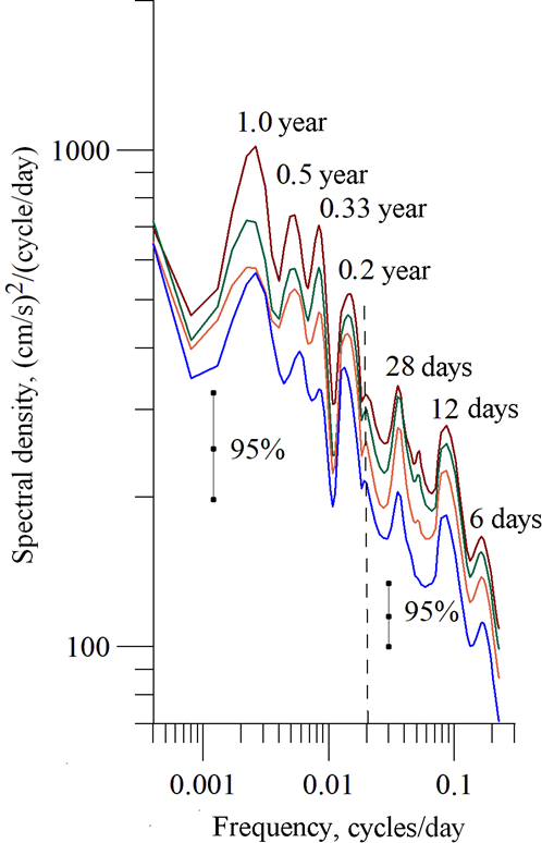
F i g. 1. Average long-term full energy spectra of the coastal current intra-annual variability in the range of periods 4 days – 6 years at horizons 5, 10, 15, 20 m (red, green, orange and blue lines, respectively) for 2002–2023 at the 95% confidence intervals for the ranges 4–50 days and 50 days – 6 years (vertical dashed line corresponds to the 50-day period)
A similar type of spectrum of seasonal sea surface level oscillations was previously obtained in the study of altimetry data of long-term remote satellite probes of the Black Sea level, with long-term level oscillations identified on an annual and semi-annual basis, caused by the corresponding seasonal variations in the tangential stress of wind friction [22]. In this study, it was observed that the spectral maxima of the level oscillations near the lowest annual harmonics correspond to the intrinsic variability of the Black Sea water circulation. The application of the analytical filtering procedure in the processing of time realizations enabled statistically reliable identification of the spectral peak of seasonal oscillations on a period of ~ 0.2 years (Fig. 1).
The range of long-term inter-annual oscillations of currents in the Black Sea remains the least studied both experimentally and theoretically, despite the development of such studies due to long-term contact measurements of currents carried out at MHI near the Southern Coast of Crimea. The availability of 22-year arrays of representative data from contact monitoring of the current field in the coastal zone has provided new empirical results on the problem under study. Fig. 2, a shows the energy spectra of inter-annual variability of the coastal current, calculated at each measurement horizon, where spectral peaks of close intensity are figured out at periods of ~ 2.7 and 3.6 years.

F i g. 2. Average long-term estimates of full energy spectra of the coastal current inter-annual variability in the range of periods 2–16 years (shown by the numbers at energy peaks): a – at horizons 5, 10, 15, 20 m (red, green, orange and blue lines, respectively) and on average over the layer (black line with circles) at the 95% confidence interval; b – in the 5–20 m layer at the 90% confidence interval; periodograms of current oscillations (black line) and the North Atlantic Oscillation index (red line) are shown in fragment c
When analyzing the relative variability of spectral density levels (Fig. 1; 2, a), it should be noted that the differences in their values between adjacent measurement horizons do not exceed the limits of the specified 95% confidence intervals. In fact, this is true over the entire variability range. Thus, the spectra calculated in the 15-m layer of coastal waters between the 5 m and 20 m horizons are similar and statistically homogeneous. This finding enables the utilization of the entire set of data obtained in this layer for integral estimates of the spectral characteristics of the layer oscillations as a whole. The spectrum of the stationary process (Fig. 2, b) is calculated based on the formed set of centered vector data obtained in the layer. The periodogram (Fig. 2, c, black line) is calculated to determine the full spectral composition and the values of the periods of coastal current oscillations contributing to the implementation under study. The spectrum estimate indicates that significant oscillations over periods of ~ 7.1 and 10.7 years contribute to the set of vector-centered mean annual variations obtained for 2002–2023, along with coastal current oscillations over periods of ~ 2.7, 3.6, and 5.3 years.
At present, scientific and theoretical studies of the relationships between long-term (climatic) oscillations of circulation processes in the World Ocean, atmosphere, and hydrosphere and actual variability of solar activity are being intensively developed [23–25]. The problem of assessing the role and characteristics of long-term variations in ocean and atmospheric waters in the formation of climate change has been discussed in domestic scientific publications since 1936. In [26], an analysis of auto-oscillations in the ocean – atmosphere – continent system was conducted to study the causes of long-term inter-annual oscillations in the Atlantic current regime. This analysis yielded an estimate of the period of oscillations under study, which was determined to be ~ 3.5 years. According to [27], the 5-year cyclicity is expressed in the Southern Oscillation (SO) and in the data on wind variability in the tropics, while 4–5-year oscillations in zonal temperatures were identified by statistical and spectral analysis of a set of long-term field data. As stated in [23], short-term climatic variations in the ocean – atmosphere system with typical periods ranging from 2 to 7–8 years are of global nature and can be reliably identified in different regions of the globe using various data types. The inter-annual variability of hydrometeorological fields in the Northern Hemisphere is most significantly reflected in the long-range climatic North Atlantic Oscillation (NAO) and the SO [23–25]. As demonstrated in [28], the analogue of the NAO index and the Black Sea level exhibit a 22-year cyclicity. The inter-annual variability of these characteristics is associated with the features of the phases of the 11-year solar cycle, resulting in noticeable differences in the formation of atmospheric circulation conditions. A stable trend emerges in the variability of the Rim Current intensity and the spatial structure of two macrocyclonic gyres of the Black Sea currents.
A comparison is made between the spectral composition of short-period climatic oscillations of the Black Sea coastal zone current (Fig. 2, c, black line) and inter-annual oscillations of the climatic NAO index (Fig. 2, c, red line). The data concerning the variability of monthly average NAO index can be accessed via https://origin.cpc.ncep.noaa.gov/products/precip/CWlink/pna/norm.nao.monthly.b5001.current.ascii.table. The inter-annual variation of the annual average NAO index values was computed from the sequence of monthly average values, and an estimate of the spectrum of these oscillations was calculated as well. When analyzing the spectral composition, significant climatic oscillations of the NAO index with periods of ~ 2.5, 3.6, 5.8 and 10.7 years (Fig. 2, c, red line) were identified. These periods exhibit close values with the corresponding periods (~ 2.7, 3.6, 5.3 and 10.7 years) of the coastal current oscillations in the Black Sea (Fig. 2, c, black line). It should be noted that despite the proximity of the compared values of the inter-annual oscillations’ periods, in the studied range of variability of hydrometeorological fields in the NAO index oscillations, the spectral peak at a period of ~ 7 years is not manifested (Fig. 2, c).
Characteristic of the components of inter-annual current oscillations. As a result of applying the vector centering procedure to the 22-year inter-annual variations of smoothed annual average values of the velocity module (Fig. 3, a) and the direction of the current vector (Fig. 3, b), inter-annual variations in the velocity module (Fig. 3, c) and the direction (Fig. 3, d) of the centered current vector at 5–20 m layer horizons were formed. The smoothing procedure was performed in order to minimize the contribution of along-coastal current oscillations with periods of less than 3 years.

F i g. 3. Inter-annual variations of smoothed average annual values of current module (a) and direction (b) of the components of initial current vectors at horizons 5, 10, 15, 20 m (red, green, orange and blue lines, respectively) and their vector-averaged (in the 5–20 m layer) values (black lines with circles), as well as inter-annual variability of the components of corresponding centered current vectors: current module (c) and direction (d) in the 5–20 m layer
The inter-annual oscillations of velocity modules and directions of the centered current vectors over the periods of ~ 5 and 7 years have values that closely resemble those of each year at all measurement horizons. Vector averaging was performed on the components of the centered current vectors in the 5–20 m layer. Subsequently, smoothed estimates of their integral components were calculated (Fig. 4, b, c). The application of smoothing was implemented in order to minimize the contribution of current oscillations with 5-year periods.

F i g. 4. Inter-annual variations in the smoothed annual average Wolf number (a), current module (b) and direction (c) of the vector-averaged (in the 5–20 m layer) centered current vector. Vertical solid lines are the boundaries of the 24th standard solar cycle, and blue horizontal line corresponds to the west-southwest direction (237°) of the stationary along-coastal current
The data on inter-annual variations in the annual mean Wolf number are available at https://www.side.be/SILSO/ssngraphics. Three full periods of 7-year oscillations of the centered current vector, corresponding in time to certain phases of the 23rd, 24th, 25th solar activity cycles (Fig. 4, a), are identified explicitly in Fig. 4, b due to smoothing. Fig. 4, c shows a smoothed realization of a complete cyclonic reversal of the current oscillation direction over a 22-year measurement period. At the same time, during 2006–2015, the along-coastal water movement during 7-year oscillations of the coastal current occurs practically in phase, and in the years 2002–2003 and 2020–2023, it displays an antiphase relationship with the general direction of the along-coastal current (solid blue line at 237°). Thus, the along-coastal current composition contains a directionally changing contribution of the 7-year oscillation vector, which leads to periodic changes in the velocity module of the stationary current. In the initial current variations shown in Fig. 3, a, the average annual velocity modulus in 2014 reached a maximum value of 9.4 cm/s, and subsequently decreasing to 5.8 cm/s in 2020. This phenomenon can be attributed to the periodic variability of the contribution of the identified long-term current oscillations. The identified long-term oscillations of coastal waters are synchronized with short-period climatic variations in their temporal scales. They are actively studied in the atmosphere and ocean due to their special role in the formation of changes in the climate system.

F i g. 5. Inter-annual variations in the smoothed annual average values of the current module (a), direction (b) and hodograph (c) corresponding to a 22-year circulation cycle of the vector-averaged (in the 5–20 m layer) centered current vector with minimization of the oscillation (with periods ˂ 7 years) contributions
During the vector filtering of 7-year current oscillations in inter-annual variations of smoothed annual average values of velocity module (Fig. 5, a), 11-year oscillations with a complete 360° reversal of the direction (Fig. 5, b) of the centered current vector were identified upon completion of the 22-year measurement cycle. Figure 5, c shows the corresponding ellipse-shaped hodograph with cyclonic rotation of the annual average velocity of the centered current vector. The hodograph, constructed in the right-hand orthogonal coordinate system oriented to the north, demonstrates an almost complete 22-year cycle of current velocity vector rotation for the 2002–2023 period. Axial lines of the ellipse in Fig. 5, c indicate the orientation of the current vector in 2005, 2011, 2016 and 2022 in accordance with the extreme values of the velocity module oscillations (Fig. 5, a).
The results of the study on the variability characteristics of long-term current fluctuations in the coastal zone serve as an informative indicator of climatic variability of the Black Sea current system. Fig. 4, a demonstrates the inter-annual variations in the average annual values of the Wolf number, according to which the performed studies of currents are confined to the second half of the 23rd (odd), the first and second halves of the 24th (even) and the first half of the current 25th (odd) standard 11-year solar cycle. As demonstrated in [29–31], odd and even solar cycles play a distinctive role in the formation of inter-annual variability within hydrometeorological fields. At the same time, [29] observes that the time periods (with increased solar activity) that include the second half of the even and the first half of the odd standard solar cycles are particularly intense. The intensification of solar activity during the second half of the 24th even and the first half of the 25th odd current solar cycle (Fig. 4, a) from 2007 to 2020 resulted in a gradual increase of 1.5 times in the velocity module of inter-annual current oscillations (Fig. 3, c; 4, b). The previous phase of solar activity decline was observed in the second half of the 23rd solar cycle from 2002 to 2008, and the next phase of decline, according to [29], occurs in the second half of the 25th cycle after 2023.
As indicated in [30], the long-term oscillations of hydrometeorological fields are possible due to the combined influence of solar activity effects with periods of ~ 11 years and the dynamics of the underlying atmosphere with periods of ~ 2–7 years. The findings presented in this study and the availability of the necessary materials for long-term complex monitoring of currents and hydrometeorological conditions at MHI, make it possible to continue field studies of the long-term dynamics of coastal waters and circulation processes within the Black Sea region atmosphere, encompassing the spectrum of inter-annual (intradecadal) and interdecadal variability.
Conclusion
Marine Hydrophysical Institute of RAS has identified the study of the variability features of the Black Sea’s long-period oscillations near the coastline as a priority task. These oscillations directly affect the dynamics of marine ecological and economic processes in the coastal zone near the Southern Coast of Crimea. The use of verified informational technology for contact monitoring ensured the metrological unity of the recorded values of vertical structure characteristics of the coastal current horizontal components with the utmost accuracy of instrumental measurements of their vector-averaged values. In a novel approach to the full-scale experimentation in the Black Sea coastal zone, the characteristics of long-period (seasonal and inter-annual) oscillations of quasi-stationary coastal currents have been identified, studied, and systematized. The structure and composition of short-period climatic variations of the coastal current, concentrated in the variability range of 2.7–7.1 years, as well as 11-year oscillations of the current within a 22-year variability cycle, are studied. A comparison of the spectral composition of inter-annual oscillations of the Black Sea coastal current and the corresponding NAO index oscillations reveals several periods of significant similarity. It is determined that an increase in the velocity module and a reversible change in the phase of the current inter-annual oscillations in the period 2007–2020 occur simultaneously with the intensification of solar activity. These analytical results provide a foundation for further investigation into the long-period variability characteristics of the Black Sea coastal current system.
1. Ivanov, V.A. and Belokopytov, V.N., 2013. Oceanography of the Black Sea. Sevastopol: ECOSI-Gidrofizika, 210 p.
2. Korotaev, G., Oguz, T., Nikiforov, A. and Koblinsky, C., 2003. Seasonal, Inter-annual, and Mesoscale Variability of the Black Sea Upper Layer Circulation Derived from Altimeter Data. Journal of Geophysical Research: Oceans, 108(C4), 3122. https://doi.org/10.1029/2002JC001508
3. Ovchinnikov, I.M., Titov, V.B. and Krivosheia, V.G., 1986. New Data on the Time Variability of Currents According to the Results of Perennial Measurements from a Stabilized Buoy of the Black Sea Shelf. Doklady Akademii Nauk SSSR, 286(5), pp. 1250-1254 (in Russian).
4. Krivosheya, V.G., Moskalenko, L.V. and Titov, V.B., 2004. On the current regime over the shelf near the North Caucasian coast of the Black Sea. Oceanology, 44(3), pp. 331-336.
5. Serebryany, A. and Lavrova, O., 2008. [Anticyclonic Eddy on the Northeastern Black Sea Shelf: Joint Analysis of Satellite Images and Acoustic Probing Data of the Water Column]. Sovremennye Problemy Distantsionnogo Zondirovaniya Zemli iz Kosmosa, 5(2), pp. 206-215 (in Russian).
6. Demyshev, S.G. and Evstigneeva, N.A., 2016. Modeling Meso- and Submesoscale Circulation along the Eastern Crimean Coast Using Numerical Calculations. Izvestiya Atmospheric and Oceanic Physics, 52(5), pp. 560-569. https://doi.org/10.1134/S0001433816050042
7. Zatsepin, A.G., Elkin, D.N., Korzh, A.O., Kuklev, S.B., Podymov, O.I., Ostrovskii, A.G. and Soloviev, D.M., 2016. On Influence of Current Variability in the Deep Black Sea upon Water Dynamics of Narrow North Caucasian Continental Shelf. Physical Oceanography, (3), pp. 14-22. https://doi.org/10.22449/1573-160X-2016-3-14-22
8. Belokopytov, V.N. and Nikol´sky, N.V., 2015. Stationary Anticyclonic Eddies Near the South and West Coasts of Crimea. Ecological Safety of Coastal and Shelf Zones of Sea, (1), pp. 47-53 (in Russian).
9. Kuznetsov, A.S., 2022. Mean Long-Term Seasonal Variability of the Coastal Current at the Crimea Southern Coast in 2002-2020. Physical Oceanography, 29(2), pp. 139-151.
10. Kuznetsov, A.S. and Ivashchenko, I.K., 2023. Features of Forming the Alongcoastal Circulation of the Coastal Ecotone Waters nearby the Southern Coast of Crimea. Physical Oceanography, 30(2), pp. 171-185.
11. Ivanov, V.A., Kuznetsov, A.S. and Morozov, A.N., 2019. Monitoring Coastal Water Circulation along the South Coast of Crimea. Doklady Earth Sciences, 485(4), pp. 405-408. https://doi.org/10.1134/S1028334X19040044
12. Koveshnikov, L.A., Ivanov, V.A., Boguslavsky, S.G., Kazakov, S.I. and Kaminsky, S.T. 2001. Problems of Heat and Dynamic Interaction in a Sea–Atmosphere–Land System of the Black Sea Region. In: MHI, 2001. Ecological Safety of Coastal and Shelf Zones and Complex Use of Shelf Resources. Sevastopol: MHI. Iss. 3, pp. 9-52 (in Russian).
13. Efimov, V.V., Shokurov, M.V. and Barabanov, V.S., 2002. Physical Mechanisms of Wind Circulation Forcing over the Inland Seas. Izvestiya Atmospheric and Oceanic Physics, 38(2), pp. 217-227.
14. Efimov, V.V., Barabanov, V.S. and Krupin, A.V., 2012. Simulation of Mesoscale Features of Atmospheric Circulation in the Crimean Black Sea Region. Morskoy Gidrofizicheskiy Zhurnal, (1), pp. 64-74 (in Russian).
15. Ivanov, V.A. and Yankovsky, A.E., 1993. Local Dynamic Experiment in the Shelf Zone of Southern Crimean Coast. Okeanologiya, 33(1), pp. 49-56 (in Russian).
16. Kuznetsov, A.S., 2023. Spectral Characteristics of Wind Variability in the Coastal Zone of the South Coast of Crimea 1997–2006. Ecological Safety of Coastal and Shelf Zones of Sea, (2), pp. 6-20.
17. Kuznetsov, A.S., 2024. Peculiarities of Interseasonal Variability of Alongshore Wind Circulation and Coastal Currents off the Southern Coast of Crimea. Ecological Safety of Coastal and Shelf Zones of Sea, (1), pp. 31-44.
18. Ivanov, V.A. and Dulov, V.A., eds., 2014. Monitoring of the Coastal Zone in the Black Sea Experimental Sub-Satellite Testing Area. Sevastopol: ECOSI-Gidrofizika, 526 p. (in Russian).
19. Timchenko, I.E. and Igumnova, E.M., 2011. Control over the Ecological-Economic Processes in the Integral Model of the Coastal Zone of the Sea. Physical Oceanography, 21(1), pp. 45-62. https://doi.org/10.1007/s11110-011-9103-9
20. Bayankina, T.M., Godin, E.A., Zhuk, E.V., Ingerov, A.V., Isaeva, E.A. and Vetsalo, M.P., 2021. Information Resources of Marine Hydrophysical Institute, RAS: Current State and Development Prospects. In: T. Chaplina, ed., 2021. Processes in GeoMedia – Volume II. Cham: Springer, pp. 187-197. https://doi.org/10.1007/978-3-030-53521-6_22
21. Ozmidov, R.V., 1964. Some Data on Large-Scale Field Characteristics of Horizontal Velocity Components in the Ocean. Izvestiya AN SSSR. Seriya Geofizicheskaya, (11), pp. 1708-1719 (in Russian).
22. Korotaev, G.K., Saenko, O.A. and Koblinsky, C.J., 2001. Satellite Altimetry Observations of the Black Sea Level. Journal of Geophysical Research: Oceans, 106(C1), pp. 917-933. https://doi.org/10.1029/2000JC900120
23. Polonsky, A.B., 2019. The Ocean’s Role in Climate Changes. Newcastle upon Tyne: Cambridge Scholars Publishing, 270 p.
24. Palmén, E. and Newton, C.W., eds., 1969. Atmospheric Circulation Systems: Their Structure and Physical Interpretation. New York, London: Academic Press, 603 p.
25. Bigg, G.R., Jickells, T.D., Liss, P.S. and Osborn, T.J., 2003.The Role of the Oceans in Climate. International Journal of Climatology, 23(10), pp. 1127-1159. https://doi.org/10.1002/joc.926
26. Shuleikin, V.V. and Ershova, N.D., 1936. [The Reason for Periodic Fluctuations in the Regime of the Atlantic Currents]. Doklady Akademii Nauk SSSR, I(5), pp. 217-222 (in Russian).
27. Monin, A.S. and Shishkov, Yu.A., 1998. The 5-Year Cyclicity of Global Weather. Doklady Earth Sciences, 358(1), pp. 128-131.
28. Sizov, A.A. and Belokopytov, V.N., 2004. Peculiarities of Hydrometeorological and Hydrological Fields of the Black Sea at a Decline Phase of 11-Year Solar Activity Cycle. Ecological Safety of Coastal and Shelf Zones and Complex Use of Shelf Resources, 10, pp. 109-118 (in Russian).
29. Cliver, E.W., Boriakoff, V. and Bounar K.H., 1996. The 22-Year Cycle of Geomagnetic and Solar Wind Activity. Journal of Geophysical Research: Space Physics, 101(A12), pp. 27091-27109. https://doi.org/10.1029/96JA02037
30. Mikhalev, A.V. and Medvedeva, I.V., 2009. Solar Cycles in Variations of the 557.7 nm Emission. Optika Atmosfery i Okeana, 22(9), pp. 896-900 (in Russian).
31. Apostolov, E.M., Altadill, D. and Todorova, M., 2004. The 22-Year Cycle in the Geomagnetic 27-Day Recurrences Reflecting on the F2-Layer Ionization. Annales Geophysicae, 22(4), pp. 1171-1176. https://doi.org/10.5194/angeo-22-1171-2004