


Russian Federation
Russian Federation
Russian Federation
Purpose. The purpose of the study consists in obtaining modern accurate data on the bottom relief features and the granulometric composition of bottom sediments in Limenskaya Bay region of the Southern Coast of Crimea. Methods and Results. The samples of the surface layer (0–5 cm) of bottom sediments were taken using the Peterson grab sampler in September 2022. The granulometric composition of bottom sediments was studied using the decantation and scattering method. The hydroacoustic research of the seabed was performed from the small vessels of Marine Hydrophysical Institute and the Black Sea Hydrophysical Subsatellite Polygon in 2022 and 2023. The Lowrance Elite FS7 instrument which includes a built-in single-beam echo sounder (200 kHz) for determining the sea depth, the side-scan sonar (455/800 kHz) and the global satellite navigation system receiver for defining the coordinates was applied. It is noted that at present, the sea bottom in the coastal part and in Limenskaya Bay sublittoral is covered with the unevenly distributed sedimentary material of heterogeneous composition. In the shallowest part (0–10 m), the boulder-pebble forms of sediments are widespread, their active movement is a result of storm impact and anthropogenic activity. Conclusions. The predominance of gravel fraction in the western and eastern study areas results from the landslide-prone coastal morphology. In the deeper parts (10–15 m) of Limenskaya Bay, the bottom is covered mainly with the well-sorted sand sediments. At the depths exceeding 20 m, the proportion of silt fraction increases, which is consistent with the previously studied features of general dynamics of sediment fractions in this region. Having been deciphered, the results of bottom relief hydroacoustic scanning in the coastal zone made it possible to outline the boundaries of boulder-pebble area, as well as to estimate the predominant sizes at various parts of the bottom
Black Sea, sublittoral, Limenskaya Bay, bottom sediments, granulometric composition, bottom relief

Introduction
Bottom sediments are one of the most informative elements of the natural environment of the coastal zone of the sea. They accumulate pollutants entering the sea and enable characterization of the presence and development of negative biogeochemical processes, both in the sediments and in the water column [1]. The surface layer of bottom sediments is the most dynamically active, its state being determined both by rapid synoptic processes at the atmosphere-sea boundary and slower processes of sedimentogenesis at the sea-bottom boundary.
It is the surface layer of sediments on the beach and in the near-shore zone of the sea that determines the recreational attractiveness of the coast, and in deeper water areas it is important for monitoring the ecological state of the coastal zone and for estimating the geomorphological characteristics of a coastal section when planning construction [2, 3].
The Southern Coast of Crimea (SCC) is a unique region due to its diverse landscapes and biocenoses [4]. A large number of recreational infrastructure facilities are concentrated along its coastline – health resorts and complexes [2, 3, 5]. The SCC characterized by a high density of development.
The study of meteorological, hydrological, hydrochemical and optical characteristics of the SCC waters in general and Limenskaya Bay in particular has been carried out over a long period of time [6–10] at the Black Sea Hydrophysical Subsatellite Polygon (BSHSP), partly due to the location of the stationary oceanographic platform of Marine Hydrophysical Institute (MHI) of the Russian Academy of Sciences in the waters of the bay [11].
Despite great interest in the research of the coastal areas of the SCC, detailed studies of the characteristics of the modern structure of the bottom relief in the coastal and near-shore zones, as well as the grain size distribution of bottom sediments in the waters of Limenskaya Bay have not been carried out. The main information on the grain size distribution of the bottom sediments in Limenskaya Bay dates back to the middle and second half of the 19th century and is presented in the works , and the main factors controlling the flow of terrigenous material into the bay waters are described in the works [12, 13]. Among the most recent studies devoted to the grain size distribution of bottom sediments and their dynamics in the waters of Limenskaya Bay and adjacent areas of the SCC, the works [14–16] can be noted. However, based on the data on the sedimentation rates in the coastal areas of Crimea [17, 18], it can be assumed that the previously obtained information on the structure of sediments is very outdated, does not reflect the real picture and requires updating. The acquisition of new data will make it possible to study in more detail the characteristics of the formation of bottom sediments under anthropogenic load.
The purpose of the study is to obtain modern, accurate data on the bottom relief characteristics and granulometric composition of the bottom sediments in the Limenskaya Bay region of the SCC.
Characteristics of the research area
The study area spans 0.8 × 4 km water body covering the coastal (1–10 m depth) and sublittoral (10–40 m depth) sections of the SCC shelf in the vicinity of Limenskaya Bay between Katsiveli and Simeiz. Limenskaya Bay, or (as it is also known) Goluboy Zaliv, is a relatively shallow bay bounded to the west by Cape Kikineiz and to the east by the foot of Mount Koshka.
The Limenskaya Bay area belongs to the tectonic structure of the anticlinorium of the western part of the SCC . In general, the entire SCC from the Morskoye settlement in the east to the Batiliman tract in the west has a similar structure. The narrow coastal strip consists of clayey and sandy deposits of the Tauride series and the Middle Jurassic. It is cut through by numerous ravines and gullies, which carry surface runoff water only during flood periods. It is bounded to the north by very steep and often precipitous slopes of the Main Ridge, composed of Upper Jurassic carbonate rocks [19]. The geological structure of the bay is characterized by a complex combination of folded and faulted sedimentary rocks, including Jurassic and Cretaceous limestones, sandstones and shales . The study area contains the most significant outcrops of effusive rocks in the western part of the SCC. Due to the relatively easy destruction of the rocks that make up the coast and the steep slope, erosion processes achieve a considerable efficiency, which is expressed in the high degree of development of the gully system. The Limenka River gully is an almost permanent watercourse, fed not only by surface runoff but also by springs located along the edges of the gully [20]. The bay waters also receive purified municipal wastewater from the settlements of Katsiveli and Goluboy Zaliv and the Goluboy Zaliv Water Park [21].
The coastal area of the SCC is characterized by a shallow bay structure due to the different erosion resistance of the rocks and the presence of block piles. The SCC is characterized by steep underwater slopes and significant depth 3. The underwater slope of the Black Sea in the area of Limenskaya Bay is a gentle plain with a south-easterly slope, in places with boulders and underwater rocks. On the SCC, in areas where the bottom consists of large transported material, the slopes in the first ten meters of depth are 0.04–0.06. In areas complicated by the presence of block piles, the bottom slopes reach 0.08–0.1. In places where rocks of the Tauride series develop and an abrasion terrace is present, the slopes decrease to 0.03–0.04 1.
The past and present oceanographic characteristics of Limenskaya Bay are closely related to its geological structure. The bottom of the bay is covered by a thick layer of quaternary sediments. The sedimentary deposits of the bay provide valuable information about past changes in sea level, climate and ocean circulation. The modern composition of the bottom sediments in Limenskaya Bay is characterized by a mixture of sand, silt and gravel-shell material. In the coastal zone they were represented by medium-grained sands with the inclusion of shell material and limestone gravel, in the marine part of the polygon – by silt-pelitic silts [15]. The reason for such heterogeneity in the distribution of fractions of granulometric composition is the change in the sedimentation conditions of suspended matter, and the main source of sediment material is coastal abrasion and alongshore sediment transport during intense storms [15].
In [16] it is shown for the Limenskaya Bay water area that during the storm impact, coarse-grained material accumulates in the coastal zone in the area of capes, medium-grained fractions accumulate in the central shallow part of the bay, and fine-grained material is transported to the seaward part of the water area and accumulates due to the weakening of hydrodynamic activity. In general, the main redistribution of fractions takes place during the first 6 hours of the storm and is limited by the 20 m isobath. The main factors regulating the movement of material are depth and bottom slope.
In [22] the level of anthropogenic load on the SCC is generally considered to be extreme. In particular, on the shores of Limenskaya Bay, the beaches have been developed and filled in, a water park has been built, an underwater outlet for the Katsiveli sewage treatment plant is under construction, and a pipe has already been laid in the area of the Goluboy Zaliv settlement.

F i g. 1. Location of study area (shown in red rectangles) on the maps of the Black Sea (a) and the Southern Coast of Crimea (b), and scheme of bottom sediments sampling stations in Limenskaya Bay and the adjacent area of the SCC (c)
Materials and methods
The surface layer of bottom sediments (0–5 cm) used for analysis in this study was sampled in September 2022 using a Peterson grab sampler with an area of 0.025 m2. The location of the sampling station is shown in Fig. 1. The particle size distribution of the bottom sediments was investigated by a combined sieve analysis (decantation and dispersion method) using a set of sieves with openings of 10; 7; 5; 2.5; 2; 1; 0.5; 0.25; 0.1; 0.05 mm. The sampling data of the bottom sediments and a general description of their composition are given in Table 1.
T a b l e 1
General description of the surface layer (0–5 cm) of bottom sediments in Limenskaya Bay and the adjacent area of the SCC (sampling on September 8, 2022)
|
Station number |
Depth, m |
Characteristics of bottom sediments |
|
1 |
9 |
Coarse- and fine-grained gravel |
|
2 |
13 |
Coarse- and fine-grained gravel with shells |
|
3 |
20 |
Coarse-grained shells with coarse sand (15%) |
|
4 |
28 |
Coarse-grained shell with fine-grained sand (33%) |
|
5 |
15 |
Fine- (42%) and medium-grained (31%) sand |
|
6 |
10 |
Fine-grained sand |
|
7 |
15 |
Coarse-grained sand and small shells (26%) |
|
8 |
11 |
Coarse- (67%) and medium-grained (21%) sand |
|
9 |
7 |
Fine-grained gravel (48%) and coarse sand (15%)
|
|
10 |
12 |
Fine-grained sand (59%) with medium-grained sand (18%) and aleurite (13%) |
|
11 |
16 |
Fine-grained sand (54%) with aleurite (25%) |
|
12 |
24 |
Aleurite (66%) with fine-grained sand (23%) |
|
13 |
31 |
Large shells (35%) and coarse-grained sand (15%) |
|
14 |
25 |
Fine-grained sand |
|
15 |
17 |
Coarse- and medium-grained gravel |
|
16 |
26 |
Coarse- and medium-grained gravel |
|
17 |
15 |
Coarse-grained sand (62%) and small shells (26%) |
|
18 |
31 |
Fine-grained sand (55%) with aleurite (40%) |
|
19 |
19 |
Coarse- and medium-grained sand with fine gravel (15%) |
|
20 |
21 |
Fine- and medium-grained gravel with coarse sand (19%) |
|
21 |
12 |
Coarse shells (24%) and fine-grained sand (18%) with aleurite (23%) and pelite (20%) |
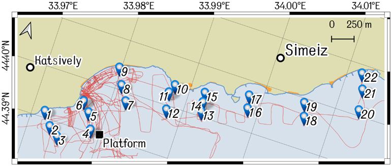
F i g. 2. Scheme of the study area. Blue markers show the sites of bottom sediments sampling, red line – the tracks of relief hydroacoustic scanning, orange polygons along the coast are the municipal beaches, and black triangle is location of the BSHSP oceanographic platform
T a b l e 2
Characteristics of expeditionary hydroacoustic studies
|
Date |
Number of points |
Length, m |
|
Date |
Number of points |
Length, m |
|
18.08.2022 |
3397 |
2548 |
|
14.06.2023 |
8001 |
6001 |
|
19.08.2022 |
8088 |
6066 |
|
15.06.2023 |
6648 |
4986 |
|
07.09.2022 |
16638 |
12479 |
|
18.07.2023 |
3670 |
2753 |
|
08.09.2022 |
32995 |
24746 |
|
20.07.2023 |
8699 |
6524 |
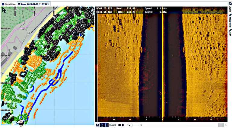
F i g. 3. Example of SSS data analysis using the ReefMaster software: left – types of deposits, right – visualization of the SSS data scanning in time; boundary between the coarse and sandy deposits is clearly seen
The hydroacoustic survey of the underwater relief was carried out from small MHI and BSHSP vessels in 2022 and 2023. A Lowrance Elite FS7 device with an integrated single-beam echo sounder (200 kHz) was used to determine the depth of the surveyed area, a side-scan sonar (SSS) (455/800 kHz) and a Global Navigation Satellite System receiver to determine the coordinates. The working area and vessel tracks are shown in Fig. 2, and information on the survey dates and track lengths is given in Table 2. Depth data were recorded with a horizontal resolution of 0.75 m with an error of up to 3 m. The accuracy of depth determination is ~ 5 cm. The SSS scanning bandwidth is up to 60 m, and the SSS beam power allowed the detection of bottom irregularities down to 40 m depth.
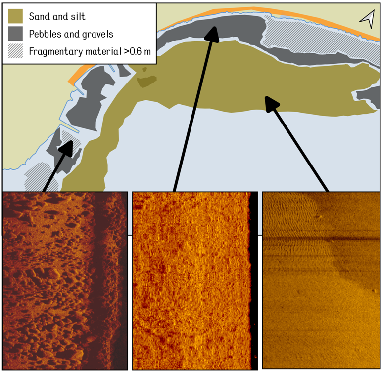
F i g. 4. Example of constructing the polygons with different types of sediments using QGIS. The data are from the expedition in 14–15.06.2023. Insets show the fragments of SSS echograms corresponding to the identified types of bottom sections
Post-processing and data analysis were carried out using QGIS GIS, Python programming language and the ReefMaster application. The initial data from the echo sounder in sqlite database format (.sl3) were loaded into the ReefMaster program (Fig. 3). Then, based on the analysis of the images obtained during the hydroacoustic survey, a point cloud was manually generated with the coordinates of the bottom sediment boundaries (boulders, pebbles, sand/silt). After defining the boundaries in ReefMaster, their coordinates were exported to a vector file (.shp). These coordinates and sediment type were then transferred to QGIS and polygons were created in semi-automatic mode to delineate areas of relatively homogeneous sediment. Three sediment types were distinguished by size: coarse-grained material and boulders (> 0.6 m), large pebbles and gravel (< 0.6 m) and sandy-silty material (< 0.1 m) (Fig. 4).
Results and discussion
Despite the uneven coverage of the study area by hydroacoustic scanning lines, as a result of the SSS data analysis it was possible to construct a set of polygons that define the position of the bottom sediment fields in Limenskaya Bay and its environs in sufficient detail.
According to Fig. 5, the bottom sediments in the coastal area (80–100 m along the normal from the water’s edge to depths of 10–15 m) are fields of large clastic material (> 0.6 m in diameter) of varying concentration, partly interspersed with a smaller fraction of pebbles and gravel, partly covered by sand sediments. In shallow water the coarse clastic deposits provide a substrate for macrophytes.
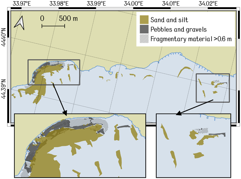
F i g. 5. Lithological scheme of the bottom surface in Limenskaya Bay and the adjacent sublittoral. The inset left part shows Limenskaya Bay, its right part – the Cape Opasny region
Near Cape Kikineiz, opposite the mouth of the Limenka River, and near Cape Opasny, large fragments predominate, while at the same depths in Limenskaya Bay, a smaller pebble fraction is more common. At 90–120 m from the shore (15–20 m depths), opposite Cape Kikineiz, large fields of fragmental material change abruptly to sand, and in the concave part of the coast they sometimes alternate with gravel and pebbles (Fig. 5). Away from the shore, at depths of more than 25 m, sands of varying sizes predominate. Moreover (as will be shown below), with increasing depth, the granularity of the sand decreases and the proportion of silt increases.
Fig. 5 shows that the polygons limiting the areas of sediments of different sizes overlap in some areas of the bottom. This is most often explained by the insignificant movement of sediments between expeditions (for example, in the western and eastern parts of Limenskaya Bay). Small overlaps are also due to errors in the determination of coordinates (± 3 m).
The most significant changes were observed on the eastern side of Cape Kikineiz, in the space between the groins in the Katsiveli beach area and to the east of it, where a relatively gentle artificial beach gives way to a narrow strip of boulders at the base of a rocky cliff. This is explained by the influx of debris under the influence of erosion processes during the flood-mudflow runoff of the Limenka River in Limenskaya Bay [23].
Also of interest is the overlap of various fields of sedimentary material in the inter-bubble space between the middle and eastern groins. This can be explained by anthropogenic influence in the form of beach replenishment with imported material, as well as the influence of storm waves.
Granulometric composition of bottom sediments
Granulometric analysis confirmed heterogeneous sediment distribution in Limenskaya Bay presented in [15]. In the shallow part of Limenskaya Bay up to 15 m depth, sandy material predominates (average content 76%), with inclusions of gravel and shell material near the shore at depths of up to 6 m (Fig. 6). Near the western (stations 5, 6) and eastern (stations 10, 11) shores of the bay, the fine-grained sand fraction (0.25–0.1 mm) with inclusions of medium-grained sand (0.5–0.25 mm) predominates, whereas in the center of the bay (stations 7, 8, 9) coarse-grained sand (1–0.5 mm) with inclusions of fine gravel and shell detritus (2–1 mm) predominates (Fig. 6). The sand fraction decreases west of Cape Kikineiz (< 40%) and increases east towards Simeiz (up to 80%). A good degree of sorting (1.3–1.4) is observed for sand material in the waters of Limenskaya Bay.
An increased gravel fraction is also observed near the coast west of Cape Kikineiz (59–97%) and east in the seaward section between Mount Koshka and Diva Rock (30–80%) (Fig. 7). The increased proportion of gravel in this section is explained by the landslide nature of the shoreline, which is composed of large boulders and blocks, and the contribution of the autochthonous component, represented by inclusions of large shells and shell detritus at stations above 20 m depth. This is confirmed by the results of the bottom measurements in this section (Fig. 5), as well as by the increased values of the median particle diameter (2–4 mm in the western part and 1.5–4 mm in the eastern part) and the poor sorting of the material (S0 = 2.1–5.9 in the western part and 2.2–3.6 in the eastern part) (Fig. 7).
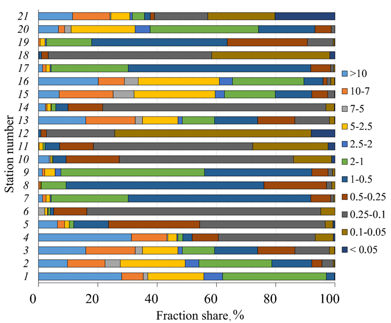
F i g. 6. Bar charts of distribution of the percentage content of size fractions in the sediments samples taken between the Katsiveli and Simeiz settlements at the SCC
The silt fraction in the samples collected is insignificant. On average, the fine-grained fraction was only 11%, of which 9% was coarse silt and 2% were fine silt and pelitic. Geographically, the minimum proportion of silt material share was recorded in the area of Cape Kikineiz (0.1–0.5%), at shallow water stations in Limenskaya Bay (0.5–0.7%) and in the area to the east of Mount Koshka (0.1–0.5%) (Fig. 7). The maximum silt fraction (41–74%) is observed in the seaward part of the study area, deeper than the 21 m isobath. This is in agreement with the results of [14, 16], which found that the dynamics of fine-grained material is limited by the 10 m isobath, with maximum values being reached from the 20 m isobath onwards. Such a low proportion of silt in the surface sediment layer, even compared to the data described in [14], is mainly explained by the sampling depth. On average, the sampling depth in 2022 was 18 m, in 2012–25 m. The increased proportion of fine-grained silt material near the eastern shore of Limenskaya Bay, as well as the increased values of the fine-grained sand fraction in this area, are associated with the abrasive nature of the coast in the central part of the bay and the peculiarities of the sediment fraction dynamics in this area.
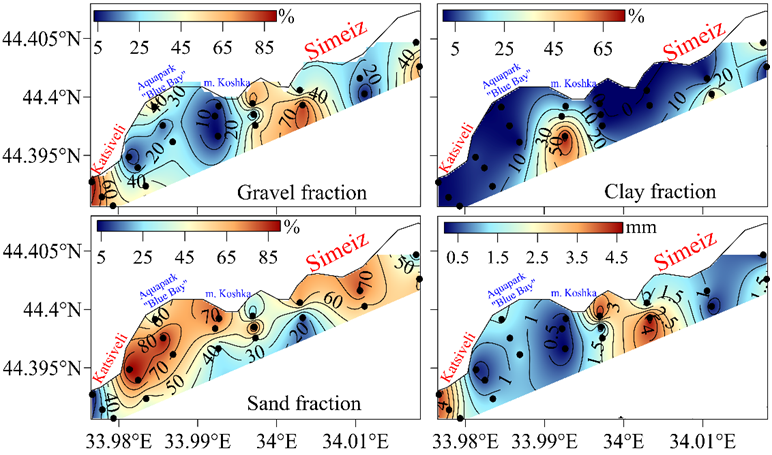
F i g. 7. Spatial distribution of particle size fractions (%) and median particle diameter (mm) in the surface layer of bottom sediments between the Katsiveli and Simeiz settlements at the SCC
For some stations (stations 2, 8, 10) in Limenskaya Bay, a comparison of the grain size distribution of the sediments with the results of previous studies in this area was additionally carried out. It was found that the results of the grain size distribution analysis at the selected stations were in good agreement, and no significant changes in the structure of the spatial distribution of sediments were observed (Fig. 8). For station 2, located in the western part of the study area in the Cape Kikineiz area, the predominance of the gravel fraction of various sizes with inclusions of coarse sand remains, and the correlation coefficient of the two-year data was 0.71. Discrepancies in the ratio of fractions in this area are explained by active hydrodynamic processes in the 10-15 m depth drop area, as well as the intensive influx of coarse gravel and pebbles from the coastal zone. This is confirmed by the results of [16], which studied the dynamics of the bottom sediments in Limenskaya Bay using numerical modeling methods. For station 8, located in the central part of the bay, the data ratio is even higher (correlation coefficient 0.90). The dominant fractions of coarse and medium sand are preserved and the proportion of fine gravel has decreased. This indicates an insignificant redistribution of material in this area. The features of accumulation of sand fractions in the center of the bay are confirmed by the results of model calculations of sediment dynamics under the influence of storm impact [16]. For station 10, located at the foot of Mount Koshka in the eastern part of the bay, changes in particle size distribution are minimal (correlation coefficient is 0.94). The change in the dominant fraction of fine sand is tenths of a percent (58.7% in 2011 and 59.1% in 2022). The decrease of the silt fraction from 28 to 13% and the increase of the coarse sand fraction from 8 to 18% are explained by the location of the station closer to the coast in 2022, as well as an insignificant redistribution of the fractions due to lithodynamic processes. In [16] it is noted that fine-grained sand and silt fractions in the eastern part of Limenskaya Bay can be shifted beyond the 14 m isobath during storm impacts.
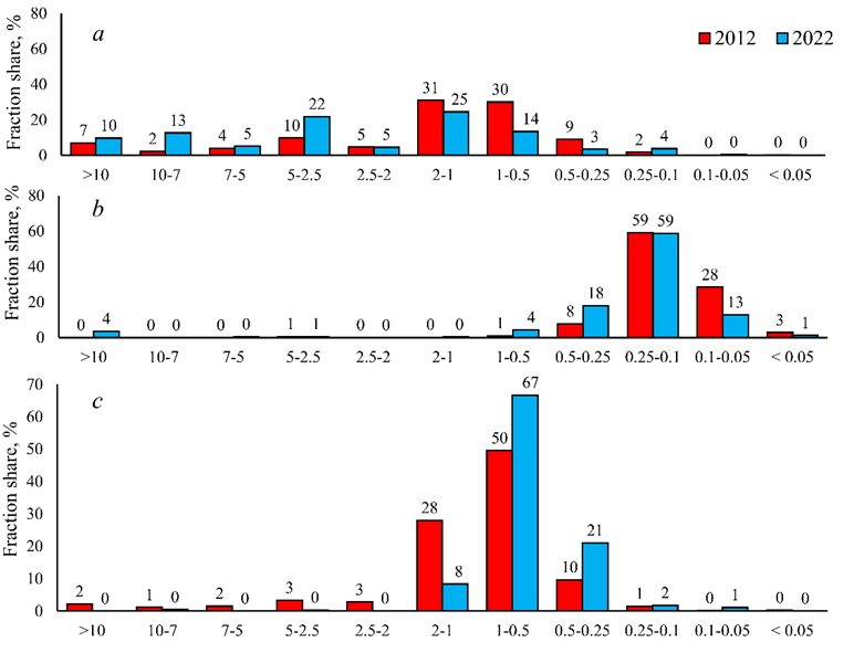
F i g. 8. Comparison of the fractions of granulometric composition of bottom sediments in Limenskaya Bay at stations 2 (а), 8 (b) and 10 (c) with the data obtained in 2012 [14]
Conclusion
This study presents an updated granulometric map of surface sediments in the sublittoral part of the shelf of the Southern Coast of Crimea in the vicinity of Limenskaya Bay. The granulometric composition of the bottom sediments is of crucial importance for the diagnosis of the ecological state of the coastal zone and the estimation of the geomorphological characteristics of a coastal area for the planning of recreational construction and coastal protection.
The obtained data show that the sea bottom in the coastal and sublittoral areas of Limenskaya Bay is currently covered with sedimentary material of heterogeneous composition and uneven spatial distribution. The shallowest part (0–10 m) is dominated by boulder-pebble sediments, which are actively moving under the influence of storm impacts and anthropogenic activity. At the same time, additional high-precision surveys are required to provide a quantitative estimate of changes in bottom relief caused by active wind and wave action. In deeper areas (5–15 m) of the Limenskaya Bay water area, the bottom is mainly covered with well-sorted sand sediments. In the western and eastern parts of the surveyed polygon, the gravel fraction predominates, which is explained by the collapse type of the shores. There is also an increase in the contribution of large shells and shell debris. At depths greater than 20 m, the silt fraction increases – consistent with known dynamics of sediment fractions in the study area. Comparison of the results with data from previous studies showed that in the central part of the bay and in the cape areas the fractional content of the fractions remains similar and that changes in the ratio of sand and gravel material can be attributed to lithodynamic processes in the coastal zone and material redistribution. Our findings align with prior studies in this region.
Methodologically, the presented paper showed that echolocation data can be used to study sedimentary material in areas of the sea bottom where sampling with a bottom grab is impossible due to the abundance of boulders and rock debris.
1. Egorov, V., 2021. Theory of Radioisotopic and Chemical Homeostasis of Marine Ecosystems. Cham, Switzerland: Springer, 320 p. (Springer Oceanography Series). https://doi.org/10.1007/978-3-030-80579-1
2. Goryachkin, Yu.N., ed., 2015. [Current State of the Crimean Coastal Area]. Sevastopol: ECOSI-Gidrofizika, 252 p. (in Russian).
3. Goryachkin, Yu.N. and Dolotov, V.V., 2019. Sea Coasts of Crimea. Sevastopol: Colorit, 256 p. (in Russian).
4. Belyaev, V.I., Doroguntsov, S.I., Sovga, E.E. and Nikolaenko, T.S., 2001. Estimation of Degree of Anthropogenic Loads on Coastal Zones and Ecotons of the Black Sea Coast of Ukraine. Morskoy Gidrofizicheskiy Zhurnal, (1), pp. 55-63 (in Russian).
5. Gurova, Y.S., Gurov, K.I. and Orekhova, N.A., 2022. Characteristics of Bottom Sediments in the Coastal Areas of the Crimean Peninsula. Land, 11(11), 1884. https://doi.org/10.3390/land11111884
6. Blatov, A.S. and Ivanov, V.A., 1992. Hydrology and Hydrodynamics of the Black Sea Shelf Zone. Kiev: Naukova Dumka, 244 p. (in Russian).
7. Goryachkin, Yu.N. and Repetin, L.N., 2009. Storm Wind and Wave Regime near the Black Sea Coast of Crimea. In: Ecological Safety of Coastal and Shelf Zones and Comprehensive Use of Shelf Resources. Sevastopol: ECOSI-Gidrofizika. Iss. 19, pp. 56-69 (in Russian).
8. Kondratev, S.I., Varenik, A.V., Vnukov, Yu.L., Gurov, K.I., Kozlovskaya, O.N., Kotelianets, E.A., Medvedev, E.V., Orekhova, N.A., Svishchev, S.V., [et al.], 2016. Blue Bay as a Sub-Satellite Ground for Evaluating Hydrochemical Characteristics in the Shelf Areas of the Crimea. Physical Oceanography, (1), pp. 48-59. https://doi.org/10.22449/1573-160X-2016-1-48-59
9. Ivanov, V.A., Kuznetsov, A.S. and Morozov, A.N., 2019. Monitoring Coastal Water Circulation along the South Coast of Crimea. Doklady Earth Sciences, 485(2), pp. 405-408. https://doi.org/10.1134/S1028334X19040044
10. Artamonov, Yu.V., Skripaleva, E.A., Fedirko, A.V., Shutov, S.A., Derjushkin, D.V., Shapovalov, R.O., Shapovalov, Yu.I. and Shcherbachenko, S.V., 2020. Waters Circulation in the Northern Part of the Black Sea in Summer – Winter of 2018. Ecological Safety of Coastal and Shelf Zones of Sea, (1), pp. 69-90. https://doi.org/10.22449/2413-5577-2020-1-69-90 (in Russian).
11. Dulov, V.A. and Ivanov, V.A., eds., 2014. Monitoring of the Coastal Zone in the Black Sea Experimental Sub-Satellite Testing Area. Sevastopol: ECOSI-Gidrofizika, 526 p. (in Russian).
12. Nasedkin, E.I., Kuznetsov, A.S., Tzikhotskaya, N.N. and Klyushina, A.K., 2005. Monitoring of Seasonal Changes in the Mineral Composition of Suspended Matter. In: Ecological Safety of Coastal and Shelf Zones and Comprehensive Use of Shelf Resources. Sevastopol: ECOSI-Gidrofizika. Iss. 12, pp. 236-241 (in Russian).
13. Nasedkin, E.I, Ivanova, A.N., Kuznetsov, A.S., Klyushina, A.K., Dovbysh, S.N. and Timofeeva, Zh.B., 2009. Some Results of Studies of the Influence of Meteorological Factors on the Processes of Modern Sedimentation. In: Ecological Safety of Coastal and Shelf Zones and Comprehensive Use of Shelf Resources. Sevastopol: ECOSI-Gidrofizika. Iss. 19, pp. 44-55 (in Russian).
14. Alekseev, D.V., 2013. [Modeling of Bottom Sediment Transport in Blue Bay Region of the Black Sea]. Reports of the National Academy of Sciences of Ukraine, (12), pp. 94-100 (in Russian).
15. Ovsyany, E.I. and Gurov, K.I., 2016. Research of Organic Carbon and Carbonate Content in the Bottom Sediments of the Crimean Southern Coast Shelf. Physical Oceanography, (1), pp. 60-70. https://doi.org/10.22449/1573-160X-2016-1-60-70
16. Gurov, K.I. and Fomin, V.V. 2017. The Dynamics of Sediments Grain-Size in Limensky Gulf. In: Proceedings of the Thirteenth International MEDCOAST Congress on Coastal and Marine Sciences, Engineering, Management and Conservation, MEDCOAST 2017. Dalyan, Mugla, Turkey: MEDCOAST Foundation. Vol. 2. pp. 925-934.
17. Denisov, V.I. 2018. Suspended Matter Fluxes in the Coastal Part of the Shelf in the Russian Sector of the Black Sea. In: The Black Sea System. Moscow: Scientific World, pp. 397-425. https://doi org./10.29006/978-5-91522-473-4.2018.397 (in Russian).
18. Mirzoeva, N.Y., Gulin, S.B., Sidorov, I.G and Gulina, L.V., 2018. Estimation of Sedimentation and Sedimentation Rates in the Coastal and Deep-Water Areas of the Black Sea Using Natural and Anthropogenic (Chernobyl) Radionuclides. In: The Black Sea System. Moscow: Scientific World, pp. 659-670. https://doi org./10.29006/978-5-91522- 473-4.2018.659 (in Russian).
19. Shestopalov, V.M., Boguslavskiy, S.G., Boguslavskiy, A.S., Ivanov, V.A. and Kuznetsov, A.S., 2005. Engineering-Geological Hazards of the Coastal Zone of the Mountainous Crimea. In: Ecological Safety of Coastal and Shelf Zones and Comprehensive Use of Shelf Resources. Sevastopol: ECOSI-Gidrofizika, (13), pp. 43-61 (in Russian).
20. Melnik, V.I., 2001. Influence of the Terrestrial River Network on Topography and Sedimentation in the Black Sea. In: Ecological Safety of Coastal and Shelf Zones and Comprehensive Use of Shelf Resources. Sevastopol: ECOSI-Gidrofizika, (4), pp. 112-124 (in Russian).
21. Kondratev, S.I., Varenik, A.V., Vnukov, Yu.L., Gurov, K.I., Kozlovskaya, O.N., Kotelianets, E.A., Medvedev, E.V., Orekhova, N.A., Svishchev, S.V., [et al.], 2016. Blue Bay as a Sub-Satellite Ground for Evaluating Hydrochemical Characteristics in the Shelf Areas of the Crimea. Physical Oceanography, (1), pp. 48-59. https://doi org./10.22449/1573-160X-2016-1-48-59
22. Goryachkin, Yu.N. and Efremova, T.V., 2022. Anthropogenic Impact on the Lithodynamics of the Black Sea Coastal Zone of the Crimean Peninsula. Ecological Safety of Coastal and Shelf Zones of Sea, (1), pp. 6-30. https://doi org./10.22449/2413-5577-2022-1-6-30
23. Boguslavsky, A.S. and Kazakov, S.I., 2021. Features of Lithodynamics of Pebble Beaches at South Coast of Crimea. In: InterCarto. InterGIS. GI Support of Sustainable Development of Territories: Proceedings of the International Conference. Moscow: Faculty of Geography MSU. Vol. 27, part 3, pp. 85-97. https://doi org/10.35595/2414-9179-2021-3-27-85-97 (in Russian).